Showing posts with label maori history. Show all posts

Thursday, 6 May 2021

Whakamaharatanga Hoia o Te Arawa


This rather interesting memorial located in one corner of the Government Gardens in Rotorua caught my eye recently.  The original idea for this came from the Ohinemutu Native Patriotic Assocation in 1919. Later the Te Arawa Trust Board took over the project and still cares for the memorial today. The board hired sculptor William Henry Feldon to design it which he did alongside local iwi (tribes).  He then created the memrial with architect Edward La Trobe Hill overseeing the project. The statue of Rangitihi, at the bottom is a replication of the original which was vandalised in 1936 created by Rakei King in 2018.

King George stands on the pedestal, below him is the star Rehua which is said to have guided the Arawa Waka (canoe) to New Zealand. 

Under this section are a tier of panels which depict: King Edward VII, Queen Victoria, King George V, a white marble cross, a navy seaman, a red cross nurse holding a floral wreath, an army soldier in a mirrored stance to the seaman.

Under another tier is a section of panels depicting: Maori weapons, local missionary Reverend Thomas Chapman, governor Hobson signing the Treaty of Waitangi under the watchful gaze of Ngati Whakaue chief Tanira Te Tupara, the God Puhaorangi looking down from the heavens at the beautiful maiden Kuraimmonoa. 

Another panel shows the Maori Regimental Badge which has 2 Maori weapons crossed under a crown, a further 2 panels which list the names of those men from Te Arawa who died during the war. The figure standing on the stone block on the steps is the Te Arawa chief Rangatihi, on the front stone block is an image of the Te Arawa waka (canoe) and lastly the Krupps field gun is thought to have been captured by the Maori Pioneer Battalion at Le Quesnoy, northern France.

Phew so that is alot of information!

Linking up with Skywatch Friday.

Saturday, 1 May 2021

Fast moving Aratiatia Dam


On one of the drizzly rainy days we spent in Taupo recently we thought it would be a bit different to visit Aratiatia Dam  to see the gates open where water would flow through to the river below. At the top normally this boat and it's owner take people out for jetboating experiences, I've done that before in Queenstown and it's really not my thing.


The huge gates had opening times of 10am, 12pm or 2pm, we chose the morning one. You can either stand on either side of this bridge and look over or walk down a designated track next to one end which is what I did.

This shot was taken while standing on the bridge facing both the gates.  The name "Aratiatia" means "Stairway of Tia" after the legendary Maori explorer Tia who first arrived at the rapids and was fascinated by the tiered form. 

This memorial stone says "This Kohatu is dedicated to the people of Ngati Tahu-Ngati Whaoa. Near the Aratiatia Rapids was the settlement 'Atahaka' one of the many Maori settlements. Atahaka had cultivations, cherry trees, burial places and a river crossing place nearby".

There were 2 tracks, this one took 10 minutes to walk down to and the other took about 30 minutes as it leads further up for a higher view.

We heard 3 loud sirens, starting at 15 minutes 5 minutes apart and then the gates slowly opened letting water through which falls 20 metres in the space of 1 kilometre. The rapids have been harnessed to produce environmentally sustainable hydro-electric power and the station was first built in 1964.


 So apart from not being allowed to swim there for obvious reasons this place was part of a memorable scene from the movie "The Hobbit - The desolation of Smaug" when the dwarves are escaping from the captivity of the elves by hiding in barrels which were thrown down stream.


Here is a video I found on youtube someone else uploaded - you'll be able to hear the siren going off at the final warning and the water rushing through the river.

Linking up with The Weekend Roundup and  Weekend Reflections.

Thursday, 18 March 2021

Pohui-nui Pa Site


Every time I drive through Kaeo I've wanted to stop and take a photo of this mountain but recently I wrangled my camera to get a shot as we drove past. Pohui-nui Pa site is just on the edge of town and you can see the layers that have been dug down the side of the hillside. 


 This particular pa site use to be fortified belonging to the Ngati Uru Tribe who arrived in Whangaroa around 1770-1775 having been drive out of the Rawhiti area of the Bay of Islands. 


As an example the pa site could've looked something like this - the layers were built into the hill to make it harder for the enemies to climb and easier for the occupatns to see who was coming up.

Linking up with Timeless Thursdays and Skywatch Friday

Thursday, 11 March 2021

Walk up to Akeake Pa Site


On Tuesday morning after B had gone to work I drove out to Opito Bay (our fishing launching spot for our boat) with the intention of exploring the nature walk there that leads to the Ake Ake Pa Site. Most nature walks managed by our Department of Conservation are dog free because of the kiwis that live in this area.


These are the first lot of steps at the start of the nature walk, weirdly enough it was at this spot I felt a sharp stabbing pain on the front of my ankle. I looked down, opened my sock and found a wasp hanging off my skin trying to sting me. After swiping it away the pain continued for another 15 minutes then gradually eased off - luckily I'm not allergic to insect stings.


This was looking back after the 2nd set of stairs - quite a nice even pathway uphill.


I was the only one there so it was so nice and peaceful even with the sound of Tuis singing away and the odd Fantail flitting around me curiously.


On my journey around the loop I counted about 6 possum traps all up. Possums here are not native, they were introduced through colonisation but now unfortunately they eat the native trees and plants so they are definitely not wanted.


At one pointed I saw this whiteboard leaning against a tree written by a Department of Conservation worker about some of the other traps that people had stolen.


After a 15 minute walk I reached the lookout point at the top of the Pa Site - amazing views looking out over the peninsula. The water is still still like a mirror - it would've a perfect day's fishing out there.


This part is the Tareha lookout point and offers views also over the Te Puna Inlet, Motupapa Island, Moturoa Island and the Kent Passage.


The original people of this Pa (maori village or defensive settlement) interacted with the earliest missionaries who sailed past on the way to the Kerikeri Mission Station (Store Store and Kemp House).


A chief named Tareha was an ally of Hongi Hika (who cut the flagpole down at Waitangi) gave his support to the local missionaries. He was well known for his bravery and skill in leading the warriors into battle.


He was also known for his huge size being a big man and large appetite. When missionary Samuel Marsden invited him on board his ship "Dromedary" there was not a large enough chair for him to sit in.


The first locality to attract the early whalers was the Te Puna area (near the river inlet), Chief Akeake would have contact with the traders through observation from the Pa.


Not much fungi up there but it's possibly the wrong time of year as we are in very early Autumn so maybe in a month or so there may be more.


Linking up with Timeless Thursdays and Skywatch Friday

Monday, 28 September 2020

Totara North Murals


At Totara North, last time I visited I drove past the local museum and stopped to admire these murals painted on various buildings.


 Painted by artist Chris Wilkie who joined up with local Bruce Sanderson, they illustrate the area's history such as the Lane and Brown timber mill.

.


The local Kauri milling industry which employed many settlers to cut down trees - apparently the man in this man is Bruce's dad, an Augustus Earle lithograph of early Maori in their Kainga (home) near the beach. 


Bruce's great great grandmother Te Waka Heremaia from Rawhiti is also featured. 


A bit more information about this little town: Totara North is a small settlement on the northern side of Whangaroa Harbour. It is home to around two hundred close-knit residents and has a primary school with 38 pupils, a community hall and gardens, The Gum Store bar and cafe, a now derelict timber mill, a wharf, a shed for crayfish processing and a boat ramp. 

The steep bush-clad hills of this northern side of the harbour tumble almost all the way into the sea and offer little flat land on which a town could grow, but prior to the 1990's when the last privately-owned kauri trees were milled, Totara North's proximity to the sea, the kauri trees and kauri gum fields, allowed it to exploit its nearby kauri forests and to become a thriving and prosperous community and a hub of commercial activity and enterprise in Northland. (information taken from from Whangaroa.co.nz)

Linking up with Mural Monday.

Tuesday, 14 July 2020

Monument to Hone Heke


Last week we drove out to 
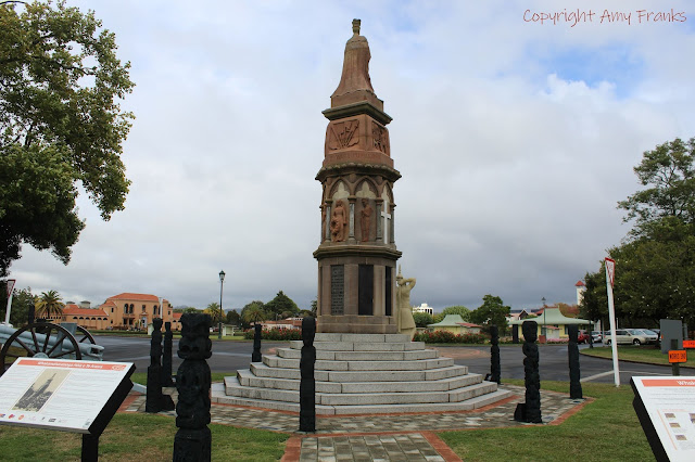
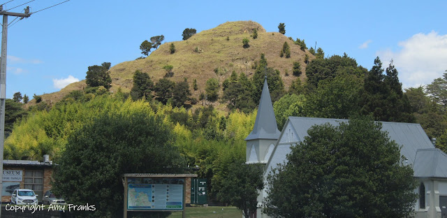
Kaikohe on one of those very blustery cold winter days and boy was it cold, we basically dodged the hail.  Anyway we decided to stop off at the Monument to Hone Heke (not the Hone Heke who was involved in the treaty of Waitangi - that was his great uncle) who was born in Kaikohe in 1869 and a direct descendant of Rahiri. He was closely affiliated with Ngapuhi and 5 other tribes.


The family and tribal home was also in Kaikohe and he attended Oromahoe and Kawakawa native schools.  After showing early promise his family sent him to St Stephen's in Parnell, Auckland. After leaving school he worked for a while driving a bullock team operating between Kaikohe and Haruru possibly for his father who owned a team of 12 bullocks.


In his youth Hone Heke became aware of the aspirations of Maori for unity and independance, initially expressed by the 1835 Confederation of the United Tribes of New Zealand. These ideas were expanded during the 1880s into the Kotahitanga movement, whose aims included control by Maori over Maori lands and a degree of influence in local government.


At the 2nd session of the Maori parliament in 1893 Hone Heke may have asked permission to speak with the assembly but because of his age he was refused.  Apparently he then addressed the people outside and when 2 of the Maori elders heard him they were impressed by his knowledge so he was asked to address the whole assembly and the whole evening was given to him.


The impact he made lead to his gaining and influential position in the movement. He worked tirelessly, travelling the country to gain support. Te Kotahitanga became the strongest unifying force between Maori and in his early 20s he was elected to the House of Representatives then further elected chairman of the Council of Paramount Chiefs.

He proved himself as a gifted speaker with an ability to state a case clearly and in an orderly fashion. In 1894 he introduced the Native Rights Bill into the house which asked for a constitution for Maori  with protection of their rights under the Treaty of Waitangi.

Throughout his parliamentary career Heke remained an advocate of legislative reform to improve conditions for Maori people and his impact in the house was huge. In 1909 around the age of 40 sadly he passed away from tuberculosis and 2 years later this memorial stone was unveiled on Kaikohe Hill. More information here.

Linking up with Our World Tuesday and My Corner of the World.

Thursday, 2 July 2020

The Waimate North Lych Gate


I was out again at the Waimate North Mission Station yesterday as it's one of my favourite historical spots in the far north.  It was a very dreary Winter's day so I spent most of the time trying to dodge the raindrops while the sun was poking it's head out hence the overcast clouds in the photo above. There is a missionary house not far off on the other side of the driveway but for this post I'd like to focus on this entranceway to the church and cemetery.


According to my research the church itself was built in 1831 but this gate was built just under 100 years later in 1929 to mark the centenary of the settlement. A tablet was also placed inside the church in commemoration of the early missionaries to the area.  Inside on the walls of the gate are plaques in honour of fallen soldiers from the area who fought in the Battle of Ohaeawai in 1845. A church service and communion were held in the open air, the unveiling in the afternoon and a Maori powhiri (welcome) afterwards. In amongst the invited guests was Bishop Bennett (the first Maori Bishop) along with 26 clergy (17 of them Maori).


There were 2 speakers on the day, Mr E.A. Ransom (Minister of Public Works) who said "the time has come for the government to recognize a greater responsibility to the Maori people in regard to the occupation of their lands. And the honourable Joseph Coates who was the prime minister from 1925 to 1928 said "there should not be differentiation between the two races. The Maori should be given the same chances as the European people" and how his father had impressed upon him that he and his fellow settlers would have starved in the early days if it had not been for the generosity of the Maori people.

To me those words should still be considered today.  Hope you're staying safe where you are. Kia kaha.

Linking up with Skywatch Friday.

Saturday, 27 June 2020

Taumarumaru Scenic Reserve


A few days ago I posted about our visit to Rangikapiti Pa site in Mangonui, this one is also another of the same but instead it's been renamed "Taumarumaru Scenic Reserve" and it's located in Cooper's Beach (Doubtless Bay).


There were suppose to be terraces and storage pits but large areas of the land was covered in scrub and weeds so apart from the walking track and miles of long grass the only thing to see was the coastline, but we definitely weren't complaining about that.


This one was a bit more of a walk than the last one, several hills to climb but worth the views on the way up.  This reserve doesn't just have 1 pa site it apparently has 3 which had historical significance to the Ngai Awa and later Ngati Kahu people. 


 It is 22ha in size and was purchased by the Crown in 1984 for public enjoyment, people are allowed to bring their dogs as long as they are on a leash.  This was the view over the coastline from the top looking towards the Mangonui and Hihi Beach area.


Looking over the other side this is the view over Cooper's Beach and Taipa.


The top track lead either way to either straight down or another one here lead down to a pristine beach with golden sand.


Once we were down there it was nice to paddle in the cool water. We get fairly mild winters up here so you can still sit on a beach and enjoy the sun when it's out.  Since we visited here on a Monday we were pretty much the only ones around.

Stay safe where you are, kia kaha.

Tuesday, 23 June 2020

A visit to Rangikapiti Pa


Road trip time! Yesterday the other half and I drove out 45 minutes to Mangonui to visit 2 historical Maori Pa sites. This was one of them - Rangikapiti Pa which was a significant site for the Ngati Kahu tribe and their ancestor Moehuri who made land fall here in his canoe.


There are amazing views over the Mangonui Harbour, terraces which were used for gardening and housing with defensive ditches around the mountain. It was extremely windy when we were standing on top so it must've been very fortified with fences for protection.


This monument was placed here in 1880 and gives tribute to what once was as well as the longitude, latitude and sea level.


Apart from some pohutukawa, most of the reserve is covered in regenerating manuka while the rest is covered in grass. This was an easy walk up hill that took us about 10 minutes and from the other side of the pa we had views over Coopers Beach and Doubtless Bay.


Here's an idea of what it would've looked like. Stay safe - kia kaha.

Wednesday, 22 January 2020

Kakaraea Methodist Church


This is a place I've been wanting to photograph for a long time. Located about 20 minutes or so out of Maungaturoto in the Kaipara along gravel roads the Kakaraea Methodist Church was first opened on Sunday March 29th 1874 and built under the direction of missionary Rev. William Gittos for the purpose of being the central church for his mission to the Maori in this region.


Unfortunately the entry door was locked so I couldn't take decent photos of the interior, so this one I had to make do with through one of the windows.  Apparently the church has special significance as the land it stands on was deliberately picked because of it's tapu (sacred) status in connection with the death of Hautatu (Chief Arama Karaka) and others at the battle of Ranganui (part of the musket wars). Otamatea Marae which is nearby and is the meeting place for the local Ngati Whatua tribe - it is still used today for events and tangis (burials).

Linking up with My Corner of the World and Skywatch Friday.

Kia ora

  Photo taken at Karangahape Road in Auckland City - November 2024. "Kia ora" is a Maori greeting said here in Aotearoa/New Zealan...